

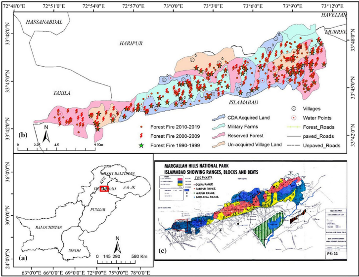
Spatio-temporal Forest fire monitoring using spatial-statistical and Geo-spatial analysis of factors determining forest fire in Margalla Hills, Islamabad, Pakistan
Related Published papers:
- Tariq, A.; Shu, H.; Siddiqui, S.; Munir, I.; Sharifi, A.; Li, Q.; Lu, L. Spatio-temporal analysis of forest fire events in the Margalla Hills, Islamabad, Pakistan using socio-economic and environmental variable data with machine learning methods. For. Res. 2021, 13, 12, doi: https://doi.org/10.1007/s11676-021-01354-4 (Journal of Forestry Research)
- Tariq, A*.; Shu, H.; Saddiqui, S.; Mousa, B.G.; Munir, I.; Nasri, A.; Waqas, H.; Baqa, M.F.; Lu, L. Forest fire Monitoring using spatial-statistical and Geo-spatial analysis of factors determining Forest fire in Margalla Hills, Islamabad, Pakistan. Geomatics, Nat. Hazards Risk 2021, 12, 1212–1233, doi: https://doi.org/10.1080/19475705.2021.1920477 (Geomatics, Natural Hazards and Risks).
DR. AQIL TARIQ
KEY POSTDOCTORAL FELLOW STATE KEY LABORATORY OF INFORMATION ENGINEERING IN SURVEYING, MAPPING AND REMOTE SENSING (LIESMARS), WUHAN UNIVERSITY, WUHAN CHINA. (PHOTOGRAMMETRY, REMOTE SENSING, GIS, GEOMATICS, SPATIAL ANALYSIS AND GEOINFORMATION)
Dr. Aqil Tariq was born in Rawalpindi, Punjab, Pakistan. Currently, he is working as postdoctoral fellow in the State key Laboratory of Information Engineering in Surveying, Mapping and Remote Sensing (LIESMARS), Wuhan University, Wuhan China. He did one Master of Science in Geography and second Master of Science in Remote Sensing and GIS. Dr. Aqil Tariq has completed his Ph.D. (Photogrammetry and Remote sensing) within a span of three years i.e. from.2018-2021. He published 17 papers during Ph.D. tenure. He has very good scientific research writing abilities. Now, he is author of more than twenty four (24) SCI/SSCI peer reviewed journal papers. He has abilities to conduct research individually. His research interest areas are 3D Geoinformation, Urban analytics, spatial analysis to examine land use/land cover, Geospatial data science, Agriculture monitoring, Forest Fire, Forest monitoring, forest cover dynamics, spatial statistics, multi-criteria algorithms, ecosystem sustainability, hazards risk reduction, statistical analysis and modelling using Python, R and MATLAB. He is also working as reviewers in high SCI/SSCI impact factor Journals. He is also member of different international science communities’ i.e. ISPRS, International Water Resources Association, International Association of Geodesy, Surveying & Spatial Sciences Institute (SSSI) and Emirati Society of GIS and Remote Sensing.