
-
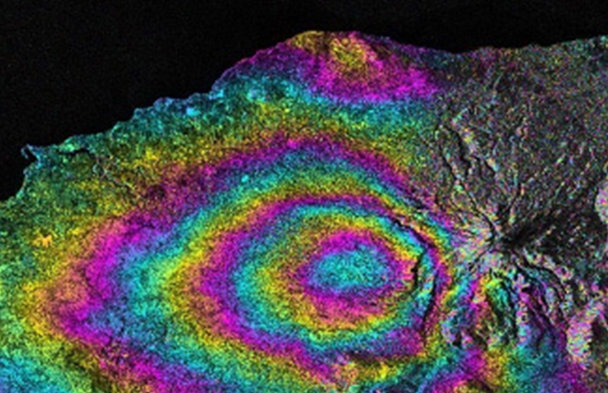
Overview on how SAR data contributes to Geohazards mapping and Damage Assessment Mapping, indicating some initiatives, software and platforms that help its exploitation
|
Monday
|
Tuesday
|
Wednesday
|
Thursday
|
Friday
|
Saturday
|
Sunday
|
|---|---|---|---|---|---|---|
|
0 events,
|
1 event,
-
Overview on how SAR data contributes to Geohazards mapping and Damage Assessment Mapping, indicating some initiatives, software and platforms that help its exploitation |
0 events,
|
0 events,
|
0 events,
|
0 events,
|
0 events,
|
|
0 events,
|
0 events,
|
0 events,
|
1 event,
-
The webinar will provide an update on ESA’s P‑band SAR mission one year after launch, highlighting its key characteristics and in‑orbit performance. It will showcase the first scientific results, including early insights into biomass |
0 events,
|
0 events,
|
0 events,
|
|
0 events,
|
0 events,
|
0 events,
|
0 events,
|
0 events,
|
0 events,
|
0 events,
|
|
0 events,
|
0 events,
|
0 events,
|
1 event,
-
The rapid expansion of Earth observation data from satellites, aerial platforms, and cloud-based archives has created unprecedented opportunities for large-scale environmental monitoring and analysis. At the same time, the volume, complexity, and velocity of these data demand new |
0 events,
|
0 events,
|
0 events,
|
|
0 events,
|
0 events,
|
0 events,
|
0 events,
|
0 events,
|
0 events,
|
0 events,
|