Skip to content
ESGRS
  • HOME
  • WEBINARS
    • WEBINARS
    • BE A GUEST SPEAKER
  • MEMBERS
    • ESGRS MEMBERS
    • MEMBERSHIPS
  • EVENTS
    • EVENTS CALENDAR
    • WORKSHOPS
    • COMPETITIONS
    • DEEP LEARNING CAMP
    • CONFERENCES
  • NEWSLETTER
  • CONTACT US
  • LOGIN/REGISTER
    • LOGIN
    • REGISTER
8 events found.

Webinars

  1. Events
  2. Webinars

Events

Events Search and Views Navigation

Event Views Navigation

  • List
  • Month
  • Day
Today
  • February 2026

  • Tue 17

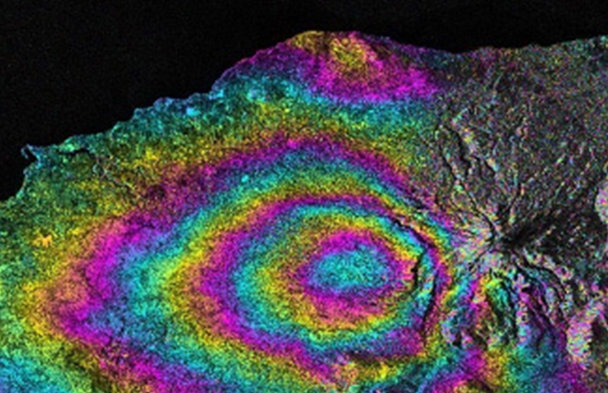
    The Contribution of Satellite Data and Artificial Intelligence for Earthquake Response with damage mapping at building level

    February 17, 2026 @ 10:00 am - 11:00 am +04
    Virtual

    The presentation will touch down on how earth observation data is currently used to detect building damages following an earthquake event. It will focus on the use of damage detection deep learning algorithms with very high resolution

  • March 2026

  • Thu 12

    Operational Satellite Radar Interferometry (InSAR) Applications for Earthquake and Ground Deformation Monitoring

    March 12, 2026 @ 10:00 am - 11:00 am +04
    Virtual

    Earthquake-induced ground deformation and slow-moving geohazards such as subsidence and landslides pose significant risks across tectonically active and rapidly urbanizing regions. Through real case studies, the session will demonstrate how multi-temporal

  • Tue 31

    The Contribution of Satellite SAR Observations for Geohazards and Disaster Assessment Mapping

    March 31, 2026 @ 12:00 pm - 1:00 pm +04
    Virtual

    Overview on how SAR data contributes to Geohazards mapping and Damage Assessment Mapping, indicating some initiatives, software and platforms that help its exploitation

  • April 2026

  • Thu 9

    ESA’s P-band SAR mission status one year after launch

    April 9, 2026 @ 10:00 am - 11:00 am +04
    Virtual

    The webinar will provide an update on ESA’s P‑band SAR mission one year after launch, highlighting its key characteristics and in‑orbit performance. It will showcase the first scientific results, including early insights into biomass

  • Thu 23

    Open-Source GeoAI for Earth Observation: Practical Tools for AI-Driven Analysis and Visualization

    April 23, 2026 @ 5:00 pm - 6:00 pm +04
    Virtual

    The rapid expansion of Earth observation data from satellites, aerial platforms, and cloud-based archives has created unprecedented opportunities for large-scale environmental monitoring and analysis. At the same time, the volume, complexity, and velocity of these data demand new

  • May 2026

  • Tue 5

    GeoAI for Environmental Management

    May 5, 2026 @ 10:00 am - 11:00 am +04
    Virtual

    Applications of various AI-based models for environmental management, including deforestation monitoring, urban tree cover change and canopy height prediction, forest health assessment, nature resources management

  • Thu 14

    Empowering the NexGen of Geospatial Intelligence Through Public-Private Partnerships

    May 14, 2026 @ 9:00 am - 10:30 am +04
    Virtual

    Join us for an introductory webinar highlighting the latest updates and capabilities of the GIQ platform and related UAE space ecosystem initiatives supporting academic, startup, and R&D entities. The session will showcase how researchers

  • June 2026

  • Wed 3

    Artificial Intelligence and Machine Learning for Agriculture Analytics

    June 3, 2026 @ 10:00 am - 11:00 am +04
    Virtual

    AI/ML plays a crucial role in agriculture analytics, especially in geospatial crop monitoring and mapping. In your research-based talk, machine learning models will be covered for classifying crops using multi-sensor temporal datasets such as optical

  • Previous Events
  • Today
  • Google Calendar
  • iCalendar
  • Outlook 365
  • Outlook Live
  • Export .ics file
  • Export Outlook .ics file

The Mohammed Bin Rashid Space Centre, founded in 2006, is home to the UAE National Space Programme.  The Centre builds and operates earth observation satellites, offering imaging and data analysis services to clients around the world.

Contact Us

+971-4-6071399

[email protected]

Copyright © 2026 ESGRS | Privacy Policy | Terms & Conditions |   

Scroll to Top